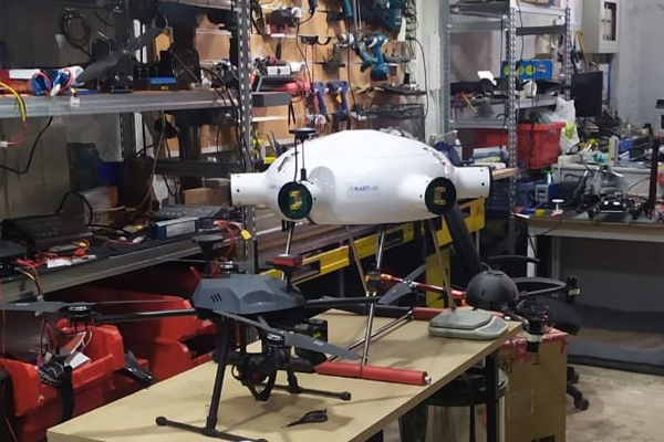
Leading the way from the sky. Discover unlimited possibilities using drone services


The Global Last Mile Delivery market is expected to reach $7.84 billion by 2026. Our technology ensured the order is delivered just the way it was packed. Using our smooth landing technology, orders are gently lowered. This ensures a quiet and secure delivery. Cruising at high speed, we reach the destination point in a fraction of conventional delivery time.
Time is critical in any emergency medical situation, and utilising drones when responding to such incidents will minimise the risk of fatalities or the chances of injuries becoming worse. Our high-precision geo-registration platform allows drone pilots flying in emergencies to have live-streamed video captured by the drone and to be automatically and accurately tagged.
Drones equipped with zoom cameras are able after an alert to take off and to scan a large crowd from above to get the whole scene, and also zoom down to pick up minute details such as individual faces, logos on a backpack, etc., while object tracking features can allow the drone to keep tabs on any suspicious characters moving through the crowd.
Our drones could deliver medications and supplies to patients being cared for in the home instead of a hospital-based setting. Our drone technology may make it easier and safer to provide this home-based care. Also our drone delivery services for ships at anchorage, for items such as spare parts, mail, stores, documentation and medical equipment could reduce the cost of these services by a factor of ten. Drones launched from onshore are capable of delivering to ships up to two miles away.
Our drones are able to enter environments and conditions that would otherwise need to be totally shutdown before a human could go into them, causing costly delays. By using our technology to gather data for inspection purposes, a drone of relatively modest cost can provide potential million savings for certain clients.
Indoor applications of our drones have less boundary conditions compared to outdoor applications. The fourth industrial revolution is affecting the warehouses since they become more digital and more connected—as in “warehouse 4.0”. New scanning technologies, bar codes, QR codes, radio frequency identification (RFID) technologies and artificial intelligence (AI) enable our drone-driven automations in warehouses.

We are a team of passionate people on innovation trying to set up the rules of the new generation applications of drones. Drones will transform our lives. In the near future hundreds of drones will fly high above towns and cities, bypassing the congested highways and streets currently plagued by traffic. Put simply, the drone revolution will change the way in which we conceive and comprehend logistics and transportation. We develop and demonstrate technology for urban Beyond Visual Line of Sight drone operations and we strongly believe that drones will have strong impact in the fourth industrial revolution. We envision Flyee as a part of this unique future global revolution.

George Voulgaroudis with a BS in Physics, a MSc in Telecommunications, and a Ph. D in Applied Informatics, he established the foundation for his successful 20-year career in technology. Throughout his tech career, George created some well-known innovative products such as the first car navigation system in Greece and the first real time traffic monitoring system in Greece. Since 2008 he is the founder and CEO of Brainbox S.A. Ιn 2014 George selected by Endeavor, an international non-profit organization, which selects and supports the most promising entrepreneurs around the world.

Dimitris Ramnalis holds a Diploma in Rural Surveying Engineering and received with a scholarship his MSc in Cartography and Geographical Analysis from the Faculty of Engineering of Aristotle University of Thessaloniki. He has numerous publications in scientific journals, international and national conferences, and workshops, and has taught at the Faculty of Engineering of Aristotle University of Thessaloniki and the International Hellenic University. Since 2004 he is co-owner and CEO of GEOSENSE.

Vasilis Polichronos holds a BSc degree in Economic studies from University of Macedonia and a MSc degree in Geographic Information System from University of Leeds. In 2002 he founded the GEOSENSE company, holding the position of CTO and head of the dept. of Unmanned Aircraft Systems (UAS). He has attended a series of training seminars on the use of UAS in Denmark and Switzerland. He is one of the five renowned trainers worldwide of the Swiss photogrammetry company Pix4D and one of the first and few UAS instructors in Greece.
